 The GSWM includes tidal forcing schemes which account for all
known sources of thermal excitation, as illustrated in the figure.
The GSWM includes tidal forcing schemes which account for all
known sources of thermal excitation, as illustrated in the figure.

Standard GSWM tidal results account for realistic tidal forcing due to ozone (absorption of solar UV radiation) and water vapor (absorption of solar IR radiation), and the effects of empirical background climatologies of zonal mean temperature, neutral density, zonal wind and ozone concentration, as well as wave dissipation.
The GSWM FORTRAN code currently runs on NCAR's Cray J90 computer. ASCII format output files containing the most recent GSWM diurnal and semidiurnal migrating tidal climatologies may be downloaded directly from this web site.
Back to Top of Model page.
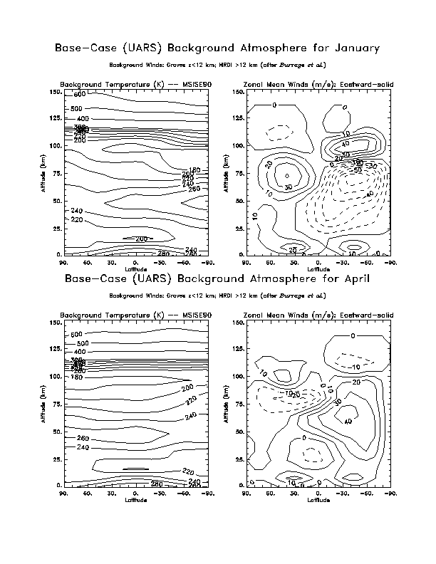
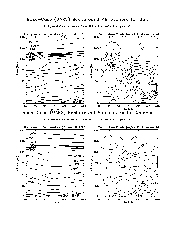
Above 12 km the standard model run uses background winds determined from measurements made by the HRDI instrument on UARS. The data are 6-year monthly and zonally averaged values that are smoothed and interpolated. Below 12km the winds are from the semiempirical model of Groves/MSIS. The GSWM background temperature and density are taken from the MSISE90 model using a 10.7-cm solar flux value of 120 and an Ap of 4. Contour plots of the GSWM standard background zonal mean temperature and wind fields are available from this web site.
The GSWM background atmosphere may be modified to explore the sensitivity of the tidal response to variable wind and temperature conditions. Results of such numerical experiments appear in the literature but are not available from this web site (please see references).
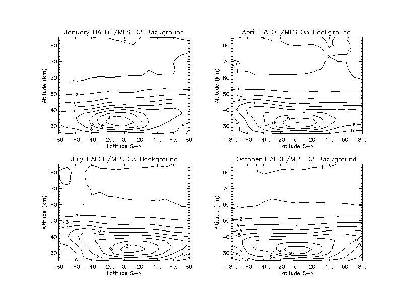
Background ozone concentrations can also be modified for numerical experiments. The standard configuration uses 6-year monthly and zonally averaged measurements from the HALOE instrument on the UARS satellite below 50 km and UARS MLS measurements above 50km. Plots of HALOE/MLS ozone used for standard model runs are available here.
Back to Top of Model page.
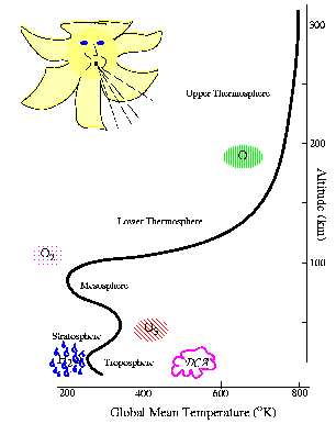
The GSWM includes tidal forcing schemes which account for all
known sources of thermal excitation, as illustrated in the figure.
In the standard model configuration only migrating sources excited by the absorption of solar radiation are specified. These include the tropospheric IR heating (blue raindrops) parameterization based on Groves (1982) which is only available for 4 months (January, April, July, October). Standard GSWM output is therefore restricted to these months which are representative of the seasons.
The standard model uses latitude and altitude-dependent ozone concentrations and the parameterization scheme of Strobel (1978) to calculate ozone (UV) forcing (red striped ellipse) in the stratosphere and lower mesosphere. The same scheme and MSISE90 molecular oxygen densities account for the absorbtion of radiation in the Schuman-Runge bands and continuum near the mesopause region (pink dotted elipse).
The current standard does not include thermospheric in-situ (EUV) forcing due to atmomic oxygen (green striped ellipse) or latent heat release due to deep convective activity (DCA pink cloud) in the troposphere. GSWM results which include latent heating effects (Forbes and Groves, 1987; Williams and Avery, 1996; Hong and Wang 1980) have appeared in the literature (please see references). Latent heating is the most significant non-migrating tidal source. Future GSWM standards will include latent heating and EUV effects.
Back to Top of Model page.
 Upward propagatig tidal amplitudes increase with altitude as the density of the
atmosphere decreases, however wave dissipation effects become important in the
middle and upper atmosphere. GSWM accounts for a number of tidal dissipation
effects as highlighted below.
Upward propagatig tidal amplitudes increase with altitude as the density of the
atmosphere decreases, however wave dissipation effects become important in the
middle and upper atmosphere. GSWM accounts for a number of tidal dissipation
effects as highlighted below.
 Gravity waves deposit momentum in the mesosphere and lower thermosphere as
they break. Their net effect is to "drag" or "stress" the winds at these
altitudes. There are significant mean wind and diurnal tidal effects,
due to the comparatively short vertical wavelength of the diurnal tide.
Gravity waves deposit momentum in the mesosphere and lower thermosphere as
they break. Their net effect is to "drag" or "stress" the winds at these
altitudes. There are significant mean wind and diurnal tidal effects,
due to the comparatively short vertical wavelength of the diurnal tide.
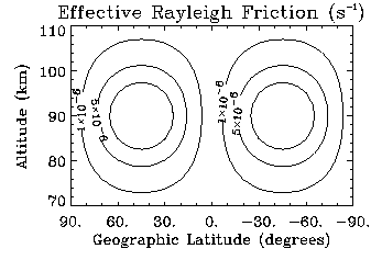
The GSWM uses an effective Rayleigh friction coefficient (after Miyahara and Forbes, 1991) in calculations of the diurnal tide to parameterize gravity wave drag effects. The figure shows the GSWM coefficients for solstice conditions. The equivalent equinoctal coefficients are an order of magnitude smaller.
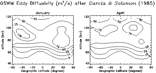
The turbulence generated by breaking or dissipating gravity waves generates diffusion effects which are felt by all tidal fields. GSWM calculates the divergence of heat and momentum flux due to eddy diffusion directly using coefficients after Garcia and Solomon (1985). Illustrations of GSWM January and April eddy diffusion coefficients indicate the magnitude of the altitudinal, latitudinal, and seasonal variations associated with this dissipative effect.
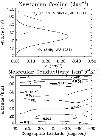
The GSWM also accounts for Newtonian cooling, latitude-dependent thermal conductivity, and ion drag effects. The figure illustrates the GSWM parameterization of Newtonian cooling effects along with thermal conductivity coefficients for January conditions.
Back to Top of Model page.
Latitude values range from 87 degrees (North) to -87 degrees (South), every 3 degrees, giving 59 measurements of each tide at each altitude. The values for each of the 4 fields is listed for each latitude at a given altitude, then this pattern is repeated for the next altitude. The output tables resemble a series of output 'blocks', one for each altitude.
The altitude of each block is indicated at the top of the block by the scale height index, X, and the corresponding geographic height, Z(km). Blocks are printed approximately every 4 km of altitude, beginning at 0km and continuing to 124km, making 31 blocks.
For example:
X= 7.6000 Z= 12.201
LAT= 87.0 U=.278E-02/ 8.5 V=.429E-02/ 5.3 W=.107E-04/ 14.2 T=.681E-03/ 11.1
...
LAT= 63.0 U=.189E-01/ 13.9 V=.188E-01/ 10.9 W=.111E-13/ 12.0 T=.192E-03/ 11.8
LAT= 60.0 U=.199E-01/ 14.0 V=.217E-01/ 11.0 W=.110E-12/ 12.0 T=.397E-03/ 12.0
LAT= 57.0 U=.243E-01/ 13.9 V=.247E-01/ 11.0 W=.435E-13/ 12.0 T=.165E-03/ 8.6
...
LAT=-87.0 U=.706E-02/ 6.4 V=.702E-02/ 10.4 W=.643E-05/ 6.8 T=.278E-03/ 15.7
...
X= 8.2000 Z= 16.218
LAT= 87.0 U=.188E-01/ 16.1 V=.120E-01/ 0.6 W=.140E-04/ 14.7 T=.115E-02/ 11.6
...
The format in pseudocode and FORTRAN to read each block is:
READ X,Z Read the altitude of this block
FOR LOOP 1 to 59 Read a Line for each of the Latitude values
READ(5x,f5.1,5x,e8.3,1x,f5.1,4x,e8.3,1x,f5.1,4x,e8.3,1x,f5.1,
4x,e8.3,1x,f5.1)
END FOR
The variables read in for each latitude value are: Latitude, U_amplitude, U_phase, V_amplitude, V_phase, W_amp,W_phz, and T_amp,T_phz. The units of amplitude/phase are m/s for the wind, degrees Kelvin for temperature, and phases are in local solar hours.
There are 4 lines at the top of the file which identify the run, including the month, the period, and the wave number. A positive wave number in the GSWM convention indicates a westward propagating component.
IDL Procedure
The following procedure is provided courtesy of Dan Marsh. It reads 31 blocks
of data. Note, the GSWM output files are described in detail above.
pro rd_gswm, gfile, lat, z, ua, up, va, vp, wa, wp, ta, tp
if (n_params() lt 11) then begin
print,'usage: rd_gswm, gfile, lat, z, ua, up, va, vp, wa, wp, ta, tp'
return
endif
ny = 59
nz = 31
s=''
openr, lun1, gfile, /get_lun
for i=0,3 do begin
readf, lun1, s
print, s
endfor
fstr1 = '(13x,f7.3)'
fstr2 = '(5x,f5.1,5x,e8.3,1x,f5.1,4x,e8.3,1x,f5.1,4x,e8.3,1x,f5.1, 4x,e8.3,1x,f5.1)'
z = fltarr(nz)
lat = fltarr(ny)
ua = fltarr(ny, nz)
up = fltarr(ny, nz)
va = fltarr(ny, nz)
vp = fltarr(ny, nz)
wa = fltarr(ny, nz)
wp = fltarr(ny, nz)
ta = fltarr(ny, nz)
tp = fltarr(ny, nz)
z1 = 0.0
dummy = fltarr(9)
for j=0,nz-1 do begin
readf, lun1, z1, form = fstr1
z(j) = z1
for i=0,ny-1 do begin
readf, lun1, dummy, form = fstr2
lat(i) = dummy(0)
ua(i,j) = dummy(1)
up(i,j) = dummy(2)
va(i,j) = dummy(3)
vp(i,j) = dummy(4)
wa(i,j) = dummy(5)
wp(i,j) = dummy(6)
ta(i,j) = dummy(7)
tp(i,j) = dummy(8)
endfor
endfor
close, lun1
free_lun, lun1
return
end
Back to Top of Model page.
Back to Top of Model page.